The mountain you see from every direction.
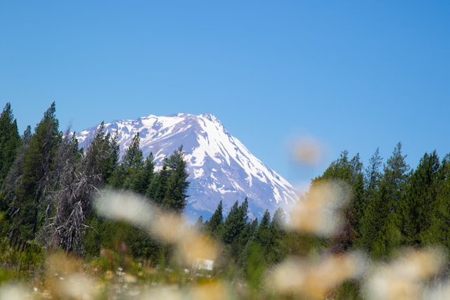
Mount Shasta is a 14,179-foot stratovolcano in Siskiyou County, the second-highest peak in the Cascade Range and — by volume — the most voluminous, at an estimated 85 cubic miles.
Most volcanoes feel finite. Shasta does not. It rises 9,772 feet above the surrounding terrain — that prominence is what makes it appear unreasonable in scale from a hundred miles away. Bay Area buyers driving I-5 to a Redding scouting trip usually first see it from the Vista Point south of Williams, more than two hours out; by the time you're descending into Mount Shasta City, the volcano is filling the windshield and the air is colder for reasons you can pin to a single object.
Geologists list its last confirmed eruption around 1250 CE and consider it likely to erupt again — there's no current indication of unrest, but Shasta is an active volcano, not a dormant one. Climbers and skiers know it for Avalanche Gulch, the standard route to the summit, which starts above the Bunny Flat trailhead at about 7,000 feet. For relocating families who don't plan to climb it, the practical role is more daily: the mountain is the orientation cue that means home. Drive north, you see it. Drive south, it disappears.
What's out there
- Mount Shasta — 14,179 ft summit
- Bunny Flat Trailhead — ~7,000 ft, standard access
- Lake Siskiyou — 430-acre Sacramento River reservoir
- Mount Shasta City — gateway town, services, breakfast
A Mount Shasta Saturday, from a Redding driveway.
I-5 north, breakfast in the city, climb to Bunny Flat for the view, swim at Lake Siskiyou on the way home. A full day, no overnight.
Drive north
Sixty-some miles up I-5, past Shasta Lake and through the Sacramento River canyon. The mountain emerges past Castella; by Dunsmuir it owns the windshield.
Breakfast and a fuel-up
Mount Shasta City is the gateway. Stop for breakfast on Mt. Shasta Boulevard, fill the tank, grab water. Local conditions and trail info are easy to find here.
Bunny Flat trailhead
Everitt Memorial Highway climbs to about 7,000 feet at the Bunny Flat parking. The road is plowed in winter as far as conditions allow. From here, day-hikers wander the lower slopes; mountaineers stage for Avalanche Gulch.
Lake Siskiyou
A 430-acre lake on the upper Sacramento River, held back by Box Canyon Dam at elevation 3,185 feet. Swim beaches, paddleboard rental, picnic tables, and the mountain reflected in the water on a still afternoon.
…and you're back in a Redding driveway by dinner
An hour and change home. That's the part that sells the move: the icon mountain is the day trip, not the vacation. If you're relocating from the Bay Area, this is part of the pitch →
Best time
June through October
Everitt Memorial Highway plows what it can in winter, but Bunny Flat is generally reliable late spring through fall. July and August are the hiking sweet spot; October gives you the early-snow contrast against the bare rock. Avoid mid-winter unless you're equipped for snow and chains.
Climbing the summit
It's a real mountaineering objective
Avalanche Gulch is the standard route — about 7,000 feet of elevation gain from Bunny Flat to the 14,179-foot summit on snow most of the climbing season, with rockfall risk and altitude effects. A summit pass and wilderness permit are required. Don't underestimate it; people get into trouble here every year.
The drive itself
~1 hour 15 minutes on I-5
From Redding it's about 68 miles up I-5 — the city of Mount Shasta sits at about 60 miles, the Bunny Flat trailhead another 14 miles east up Everitt Memorial Highway. Plan an hour and 45 to get from a Redding driveway to your boots on the trail.
Bring layers
Same-day temp swings of 30°+
It can be 95° in Redding and 50° at Bunny Flat on the same afternoon. Pack a windproof shell and water — the wind exposure at 7,000 feet is real, even when the trailhead lot is sunny.
Estimated drive time from every Shasta County area
Straight-line estimates with a road-network adjustment to the Mount Shasta landmark coordinate — useful for comparison, not turn-by-turn. From Redding, the route is I-5 north for about 60 miles to the city of Mount Shasta, then Everitt Memorial Highway east to Bunny Flat.
| From | Drive time | Distance |
|---|---|---|
| Redding | ~74 min | 67.7 mi |
| Shasta Lake | ~64 min | 58.9 mi |
| Anderson | ~88 min | 80.4 mi |
| Palo Cedro | ~76 min | 70.0 mi |
| Cottonwood | ~94 min | 86.2 mi |
| Bella Vista | ~68 min | 62.5 mi |
| Lakehead | ~43 min | 39.0 mi |
| Burney | ~66 min | 60.6 mi |
| Round Mountain | ~59 min | 54.2 mi |
| Shingletown | ~89 min | 81.8 mi |
Mount Shasta — common questions
How far is Mount Shasta from Redding?+
The city of Mount Shasta is about 60 miles north of Redding on Interstate 5 — typically a 65–75 minute drive. The peak itself is roughly 12 miles east of the city via Everitt Memorial Highway, which climbs to the Bunny Flat trailhead at about 7,000 feet.
How tall is Mount Shasta?+
Mount Shasta's summit is 14,179 feet, making it the second-highest peak in the Cascade Range. Its prominence — the height it rises above its surroundings — is 9,772 feet, which is why it appears so massive from any direction.
Can you drive up Mount Shasta?+
You can drive most of the way to the Bunny Flat trailhead at roughly 7,000 feet via Everitt Memorial Highway from the city of Mount Shasta. The road is plowed in winter as far as conditions allow. Beyond Bunny Flat, the summit is reached on foot — Avalanche Gulch is the standard route and is a serious mountaineering objective.
When did Mount Shasta last erupt?+
Mount Shasta is an active stratovolcano whose last confirmed eruption is dated to approximately 1250 CE. Geologists consider it likely to erupt again, though there's no current indication of unrest.
Homes within an hour of the mountain
Lakehead and the I-5 corridor north of Redding put the Mount Shasta drive inside a manageable Saturday morning — and the mountain becomes the daily orientation cue.