A 220-foot waterfall the National Park Service rediscovered in 2004.
Whiskeytown Falls hid in plain sight. Park staff confirmed and built access to it in 2004, naming the trail for James K. Carr, the federal official whose 1960s work brought Whiskeytown into the National Park system in the first place.
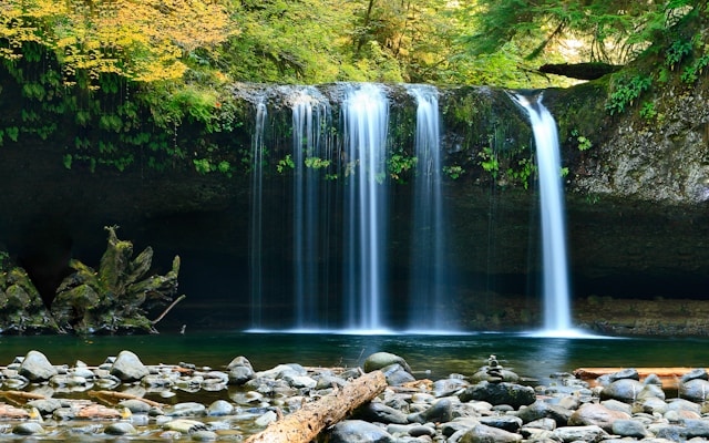
The hike is the real product. About 3.4 miles round trip with roughly 700 feet of elevation gain, the James K. Carr Trail climbs the slope above Crystal Creek under second-growth canyon live oak and Douglas fir, crosses two footbridges, and ends at a fixed-rail viewing platform underneath the upper drop. The fall itself is a true 220 feet on Crystal Creek, snowmelt-fed, so the volume swings hard between April and August — spring is loud, late summer is a contemplative spray.
It's all inside Whiskeytown National Recreation Area, which means an NPS entrance pass is required and the same Carr Fire (2018) recovery context applies. Core front-country trails like this one are open; the Park Service conditions page is the source of truth before any specific trip. For a relocating buyer, what matters is the structural point: this is the signature local hike, fifteen-twenty minutes from a West Redding driveway, with a swim beach (Brandy Creek) on the way home.
Whiskeytown Falls, shot on the trail
Not stock photos — the 220-foot drop and the Carr Trail from my own hike up. Tap any photo to enlarge.
What's out there
- Whiskeytown Falls — the 220-ft destination
- Crystal Creek Falls — alternate short walk
- Whiskeytown Visitor Center — pass, map, conditions
- Brandy Creek Beach — swim after the hike
A Saturday around the Carr Trail, from a Redding driveway.
Hike first, swim second — the order matters because Brandy Creek is a much better cold-water reward than a hot starting point.
Whiskeytown Visitor Center
Highway 299 west drops you at the visitor center on the right. Buy the 7-day pass, pick up a trail map, ask about conditions. Five minutes — but it answers the only questions worth asking before you've committed the morning.
James K. Carr Trailhead parking
From the visitor center, continue west on 299 to Crystal Creek Road. The signed trailhead lot has restrooms and shade. By 9 in summer the lot is filling — early start matters here.
Hike up to Whiskeytown Falls
About 1.7 miles each way, 700 feet of gain, two footbridges, oak shade for most of it. Allow two to three hours total — the platforms at the top are the photo, but the second tier is the conversation you'll have on the way down.
Brandy Creek Beach
The swim beach families ask me about: gradual entry, restrooms, parking that doesn't require a strategy. Lunch out of the cooler, swim off the morning's climb.
…and you're back in a West Redding driveway
That's the part that sells the move: a 220-foot waterfall hike and a swim, and you're home for dinner. See homes on this side of town →
Best season
Spring snowmelt for max flow
Crystal Creek runs hardest from late March through June on Klamath snowmelt — that's when the 220-foot face is loudest. Summer afternoons drop the volume but the trail itself is shaded and still excellent. Avoid right after a winter storm: the upper trail can ice in shade.
What to bring
More water than you'd think
Two-thirds of the climb is south-facing. Bring at least a liter per person; on a 90-degree summer afternoon, double it. Sturdy shoes (not flip-flops) — the upper handrail section is wet rock. Pack out everything; no garbage cans at the trailhead in low season.
The pass
It's NPS land — pass required
Whiskeytown is a National Park Service unit. A 7-day vehicle pass or the Whiskeytown annual pass is required to be in the recreation area. Buy online ahead or at the visitor center on the way in. The Interagency "America the Beautiful" pass covers it.
Don't skip the swim
Brandy Creek closes the loop
The Brandy Creek Beach swim is twelve minutes from the trailhead and the right way to end the day. Gradual entry, restrooms, parking. Especially in July and August, the cold-water reward is the part you remember.
Watch · the falls
The 220-foot drop, in motion
A clip from the viewing platform at the top of the Carr Trail — what the falls actually look and sound like in flow. (Final version will be a stitched reel hosted on YouTube; this is the raw clip.)
Estimated drive time from every Shasta County area
Straight-line estimates with a road-network adjustment to the falls coordinate — useful for comparison, not turn-by-turn. From Redding, the route is Highway 299 west to Crystal Creek Road.
| From | Drive time | Distance |
|---|---|---|
| Redding | ~20 min | 9.1 mi |
| Shasta Lake | ~16 min | 11.1 mi |
| Anderson | ~32 min | 22.3 mi |
| Palo Cedro | ~29 min | 20.1 mi |
| Cottonwood | ~39 min | 27.6 mi |
| Bella Vista | ~31 min | 22.0 mi |
| Lakehead | ~38 min | 26.9 mi |
| Burney | ~71 min | 64.6 mi |
| Round Mountain | ~47 min | 43.3 mi |
| Shingletown | ~50 min | 45.7 mi |
Whiskeytown Falls — common questions
How hard is the hike to Whiskeytown Falls?+
Moderate. The James K. Carr Trail runs about 3.4 miles round trip with roughly 700 feet of elevation gain. It's well-maintained, has fixed handrails on the steeper sections near the falls, and most fit hikers complete it in two to three hours including time at the falls.
When does the waterfall run hardest?+
Spring through early summer. The fall is snowmelt-fed from Crystal Creek's headwaters, so the strongest flow runs from roughly late March through June. By August the flow drops noticeably but the trail and falls remain worth the trip year-round.
Do I need a pass to hike to Whiskeytown Falls?+
Yes. Whiskeytown is National Park Service land and the standard NRA entrance pass is required — a seven-day vehicle pass or the Whiskeytown annual pass, both available online or at the Whiskeytown Visitor Center on Highway 299. The Interagency "America the Beautiful" pass is also accepted.
Are dogs allowed on the trail?+
Yes, on leash. Whiskeytown allows leashed pets on the James K. Carr Trail like most front-country trails in the recreation area. Bring water for them — the trail is south-facing in parts and gets hot in summer afternoons.
Homes 20 minutes from the trailhead
Buyers who want the Carr Trail as their default Saturday morning look hard at West Redding and the Highway 299 corridor — the same alignment that gets you to Brandy Creek beach and Whiskeytown Lake.