Three waterfalls, one short trail, springs from Mt. Shasta.
The McCloud River drops over three named falls — Lower, Middle, and Upper — in a tight stretch east of the town of McCloud, where the river finds basaltic lava flows from earlier Mt. Shasta volcanism and steps down across them.
The river itself runs 77 miles total, rising from spring-fed streams in Colby Meadows on the south flank of Mt. Shasta and eventually joining Shasta Lake to become a tributary of the Pit River. The spring-fed origin means the McCloud carries cold, clear, year-round flow — it doesn't dry up in August the way a snowmelt river does. The three falls are the showpiece of that flow.
The Forest Service manages the area within the Shasta-Trinity National Forest, with day-use parking at Lower Falls (the most popular swim hole), Fowlers Camp adjacent to Lower Falls, a connecting hiking trail up to Middle Falls (the tallest single drop of the three), and a separate day-use area at Upper Falls (the viewpoint everyone photographs). You can hike the full Lower-to-Upper sequence on the McCloud River Trail in a long afternoon, or drive between the day-use areas via Forest Road 40N44 and walk to each individually. For a relocating family looking at Mt. Shasta on the I-5 drive, McCloud Falls is the answer to "what do we actually do up here" — and it's a 70-minute drive from a Redding driveway.
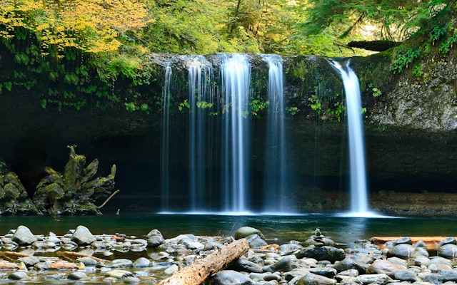
McCloud Falls, shot on my own trip up
Not stock photos — Lower Falls, the river trail, and the basalt gorge from a recent drive up. Tap any photo to enlarge.
What's out there
- Lower Falls Day Use Area — swim hole, Fowlers Camp
- Upper Falls Day Use Area — parking + trail to viewpoint
- Upper Falls viewpoint — the postcard photo
A McCloud Saturday, from a Redding driveway.
I-5 north, breakfast in the town of McCloud, walk the three-falls trail, swim at Lower Falls before driving home. Pair with Mt. Shasta if you want a longer day.
Drive north
About 70 minutes via I-5 north and the Hwy 89 east exit at Mt. Shasta City. The mountain dominates the windshield for the last forty miles; McCloud sits about 10 minutes east of that exit on Hwy 89.
Breakfast in McCloud
Small historic logging town, walkable Main Street, a couple of breakfast spots. Coffee here, then five minutes east on Hwy 89 to the Fowlers Camp / Lower Falls turn-off.
Lower Falls swim hole
The Lower Falls pool is the local swim hole — short walk from the parking lot, ledge jumps for the brave (verify depth yourself; conditions change). Day-use restrooms. Pack the lunch here; it's the practical anchor of the day.
Middle and Upper Falls
The McCloud River Trail connects Lower to Middle (the tallest single drop) to Upper Falls (the viewpoint photo) in about a mile each, mostly easy grades along the basalt-walled gorge. Or drive the day-use loop and walk to each individually.
…and you're back in a Redding driveway by dinner
An hour and change home. That's the part that sells the move: three waterfalls and a swim were a Saturday. If you want a longer day, pair it with the Mt. Shasta drive — Bunny Flat trailhead is 20 minutes from McCloud. See the Mt. Shasta page →
Best season
Late spring through fall
Spring-fed flow keeps the falls running year-round, but the Lower Falls swim hole reads best from June through September. Spring (May–June) gives the biggest visible flow at all three falls; fall (September–October) gives the cleanest light and fewer crowds.
All three
Hike or drive between
The McCloud River Trail runs Lower → Middle → Upper, about a mile each. Doable in a long afternoon as a single hike. Or drive between the day-use areas via Forest Road 40N44 and walk into each individually — useful with little kids or limited mobility.
Swim safety
Cold year-round, no lifeguards
The McCloud is spring-fed from Mt. Shasta — water temperature stays cold even in August. No lifeguards anywhere on the falls. Ledge jumps at Lower Falls are popular but conditions change; check depth and obstructions yourself every visit.
Pair with Mt. Shasta
20 minutes between them
Bunny Flat trailhead on Mt. Shasta is about 20 minutes from McCloud via Hwy 89 and Everitt Memorial Highway. If you have a full day and want the volcano + the waterfall in one trip, this is the practical loop — Mt. Shasta morning, McCloud Falls afternoon, home for dinner.
Watch · the walk-and-talk
The drive-in and the falls, on the ground
A quick clip from the trip up — what it actually looks like when you get there. (Final version will be a stitched 60–90s reel hosted on YouTube; this is one raw clip as a stand-in.)
Estimated drive time from every Shasta County area
Straight-line estimates with a road-network adjustment to the McCloud Falls coordinate — useful for comparison, not turn-by-turn. From Redding, the route is I-5 north to the Mt. Shasta City exit, then Hwy 89 east through McCloud town.
| From | Drive time | Distance |
|---|---|---|
| Redding | ~70 min | 64.6 mi |
| Shasta Lake | ~61 min | 55.8 mi |
| Anderson | ~83 min | 76.0 mi |
| Palo Cedro | ~71 min | 65.0 mi |
| Cottonwood | ~89 min | 81.7 mi |
| Bella Vista | ~62 min | 57.1 mi |
| Lakehead | ~40 min | 37.1 mi |
| Burney | ~54 min | 49.3 mi |
| Round Mountain | ~49 min | 45.2 mi |
| Shingletown | ~80 min | 73.7 mi |
McCloud Falls — common questions
How far is McCloud Falls from Redding?+
About 65 miles north of Redding via Interstate 5 and Highway 89 east — typically a 70-minute drive. The town of McCloud sits about 10 minutes west of the falls and is the practical staging point for the day.
What are the three falls?+
The McCloud River forms a series of three named waterfalls — Lower Falls, Middle Falls, and Upper Falls — where it tumbles over basaltic lava flows below Mt. Shasta. The Wikipedia article on McCloud River Falls confirms the three falls and the basalt geology; specific heights are not stated in that source.
Can you swim at McCloud Falls?+
Yes. The pool below Lower Falls is the long-popular local swim hole, with day-use access from the Lower Falls Day Use Area near Fowlers Camp. Water temperature is cold year-round — fed by springs on Mt. Shasta's south flank — but accessible in summer. No lifeguards.
How do I see all three falls?+
A McCloud River Trail connects Lower → Middle → Upper Falls on foot — about a mile between each, or you can drive between the day-use areas via Forest Road 40N44. The Upper Falls viewpoint is the postcard image; Middle Falls is the tallest single drop; Lower Falls is the swim hole.
Homes on the I-5 / Mt. Shasta drive
Lakehead and the I-5 corridor north of Redding cut the McCloud drive to under an hour, with Mt. Shasta and the Shasta Lake arms on the same route.